
Walking the “Creepy Swamp”:
the Great Marsh Trail of the Indiana Dunes National Lakeshore
May 24, 2013
We called it the “Creepy Swamp”. Driving narrow and bumpy Beverly
Drive near dusk, with hardly another soul around, we passed a forbidden looking
place full of old, dead, gnarly remains of trees, full of holes and broken
limbs, standing darkly like so many zombies rising from the stretches of dark and
shining water.
Sometimes, after heavy rains, it seemed as if this swamp
water leaked beyond the edges and over the road. Driving over the water, one could imagine being pulled back into this place of zombie trees, becoming one with it all.
Swamps are one of those things with which we humans have a
strange relationship; we are frightened and repelled by them and, at the same
time, we are drawn to their mystery. We
can imagine swamp monsters, covered in slime, that might grab our feet and pull
us in if we take one step too many. Or
we can wonder what real things might be in there: giant snakes wrapped around twisted tree
limbs? Big, slow fish that move
invisibly past our legs, their fins and whiskers brushing against our
ankles? Deep, oozy mud that sucks us
in? Or long tangles of thick algae and
vines that wrap around us when we stumble?
After spending a good part of the day on the
hot, open beach between the vastness of Lake Michigan before us and the
sweeps of Marram Grass, clusters of young Cottonwood trees, and spots of
Milkweeds on the sandy hills behind us, we would drive away to the other side
of the dunes. There it was before us,
this completely different kind of place.
Strangely, on the corner of an intersection of roads, there
was a quaint little spot with a nice bench, surrounded by thoughtful
landscaping, snuggled right up to the swamp.
Was the creator of this spot not afraid of the swamp, or was it someone
trying to make it seem friendlier, maybe taunting it?
Maybe people in this area have affection for this
place.
And what was this place?
If we knew more about it, would it seem less mysterious and
forbidding? Would it lessen the
excitement if we understood it better?
As it turns out, there are people in the area with a special
affection for this place. They live
here, or they work here through the National Park Service, or other entities
that are involved in the local environment.
Or they live far away, and have come here to learn about it, work with
it, and see that it continues to thrive.
They care so much about it that they have been involved, in one way or
another, with a restoration effort that started in 1998. They have worked hard at studying the place,
surveying, researching, planning, planting native plants, eradicating
non-native plants, and in developing trails and structures that enhance the
enjoyment and education of others who come here, while also helping to protect
the environment and its wildlife.
This swamp lies in the eastern portion of The Great Marsh of
the Indiana Dunes, which stretches roughly from Gary to Michigan City in
northwestern Indiana. After a great deal
of human impact on the Great Marsh over many years, people have been working to
preserve and protect any of it that remains, returning it to its original
form. The Great Marsh Trail of the
Indiana Dunes National Lakeshore, near the town of Beverly Shores, Indiana, is
one of the latest efforts.
On the morning of May 24, the day we were to leave the
Indiana Dunes of northwestern Indiana to head back down to the southwestern
part of the state, my husband and I decided to try out a new trail we had heard
about, this Great Marsh Trail near Beverly Shores. We drove east on one of our favorite old
highways, Route 12 (also called Dunes Highway), which runs parallel to State
Road 20 to the south and the Lake Michigan shoreline to the north. It also runs right along the railroad tracks
that carry South Shore passengers from Chicago through Dunes country, and the
Calumet Bike Trail that runs right along the railroad tracks. Route 12 runs between the ancient Tolleston
Dunes and the older Calumet Dunes, and it skirts the Great Marsh that formed
between those dunal areas (see the blog entry “The Great Marsh of the Indiana
Dunes: The Backstory”).
We turned north off of Route 12 onto Broadway, a short road
that starts just on the other side of Route 12.
It continues through the town of Beverly Shores to Lakeshore Drive,
which offers, all along the stretch of road, beautiful views below to the
dunes, beach, the lake and the Chicago skyline way out on the lake's horizon
(where the other, more famous Lakeshore Drive exists). The only road intersecting Broadway is Beverly
Drive, which divides Beverly Shores from the Great Marsh.

Here is the start of the trail, off of Broadway. You can see that it starts with a drier
stretch and then goes through a wet area, then through a longer stretch of
drier area. We will then walk to the
east, skirting the wetland, move north in a dry area, a little west, then south
through wetland again. We then return
westward, again skirting the swampy area, and dip to the southwest where we can
go to the observation deck that overlooks the largest part of the swamp. From there, we will continue southwest to the
other trail beginning, and then we will back-track and head south on the first
part of the trail to where we are parked.
Note that if you go past the observation deck to the west-south-west,
you get to the alternative trail head.
This trail head has Handicapped parking and this section of trail is
suitable for wheelchairs going to the observation deck, which has a sloped ramp
to the deck (views of the deck appear later in this entry).

Richard takes off on the first leg of the Great Marsh
Trail. This section is being converted
from industrial use to natural area. The
mowed trail is relatively new, and there are still a number of non-native and
invasive plants along the way, though strong restoration efforts are taking
place. One of the objectives of the
restoration is to “Provide recreational
opportunities for hikers, birders, botonizers, and wildlife watchers”. We were
taking advantage of the opportunity provided, of course, and there was much
more along the way.

One sign of a wet area is a stand of Cattails. These may be one of the native species
(Broad-Leaved or Narrow-Leaved), or they may be the Hybrid – I cannot tell from
this distance. Another objective of the
restoration is to “Protect rare species
by controlling non-native, aggressive plant species, and creating high quality plant and animal habitat”. One of the plants that restoration workers
are trying to control is the more invasive species of Cattail. The Hybrid Cattail is a hybrid between the
native Narrow-Leaved and the native Broad-Leaved. Both the Narrow-leaved and Hybrid can
out-compete the Broad-leaved and dominate the wetland, forming very dense
stands. To learn more about them as well
as the differences between the three, go to:
www.bwsr.state.mn.us/wetlands/plantid/Forbs/scientificname/Typhacomparecattail_comparison_08.pdf

A Pearl Crescent butterfly rests on the vegetation, sunning
its wings. A diverse, healthy habitat
attracts many different kinds of butterflies and moths that use the habitat for
shelter, moisture and sources of nectar, as well as sources of food for the
larvae.

Here we come to the first swampy area of the trail. There is evidence that the restoration teams
have been working at controlling non-native invasive plants by carefully
spraying herbicide.
Another invasive plant the teams have been trying to control
is Reed Canary Grass, a real bane to many wetland areas.


A small Black Locust tree in bloom along the trail. Black Locust is native to the east, but has
become naturalized to a great extent in Indiana. Some consider it invasive. It does not get very big, so it begins
blooming while it is still a small tree.


Someone has identified this for me (from a photo) as Field
Cress, but I would like another look at it sometime. If it is Field Cress (Lepidium campestre), it
is a non-native, introduced plant.


A group of Sensitive Fern, which loves damp places.


We move along a drier section of trail now, but toward the
swamp.


A patch of Starry False Solomon's Seal is found blooming
along the way.


We continue on a narrow, grassy path between willows.

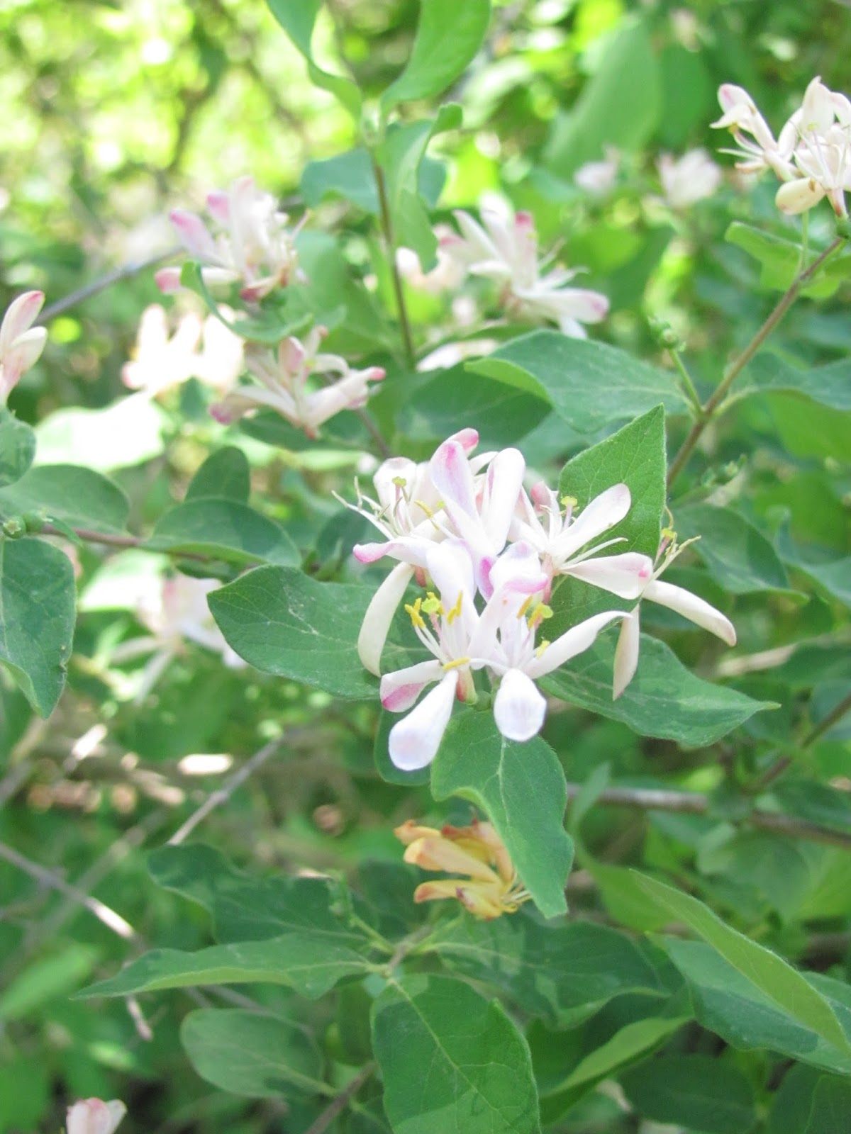
Honeysuckle blooms along the trail. I am not sure what species this is, but it
may be a non-native Bush Honeysuckle. If
so, then it is one of those invasive plants that are very difficult to
control. I hope this is a native, as the
flowers are very pretty.


We are getting nearer to the big swamp.


The swamp is just beginning to reveal itself along the trail.


I am not sure what this new, emerging plant is, but it is so
beautifully accented with bright orange.
Someone wondered if it was a new Buttonbush, but I haven’t been able to
find information on how a new Buttonbush plant looks when just emerging.


We come to the edge of the big swamp.
One of the goals of the restoration is to “Increase native plant and animal diversity”. Restoration teams try to encourage native
species that exist as well as re-introduce those that had existed in the
pre-industrial period. Diversity is the
key to a healthy ecosystem. Diverse
plant life provides more food, shelter and building materials to a diverse
animal population, increasing opportunities for all to sustain the
ecosystem.
One set of restoration teams came from the Student
Conservation Association. They worked to
control invasive species, grow native plant species in greenhouses, and plant
native seedlings into the Derby Ditch area, as well as into Cowles Bog. The following is a list of plants they added,
culled from a set of reports from the work an SCA team did in 2012 (with
botanical names and some common names):
Carex stricta Tussock Sedge, Upright Sedge, Uptight
Sedge
Carex aquatilis Water Sedge, Leafy Tussock Sedge
Carex pellita Woolly Sedge, Broad-Leaved Woolly Sedge
Carex scoparia Broom Sedge, Pointed Broom Sedge
Carex Squarrosa Squarrose Sedge
Scirpus validus Softstem Bulrush, Great Bulrush
Scirpus acutus (Schoenoplectus
acutus) Tule, Common Tule,
Hardstem Tule, Tule Rush, Hardstem Bulrush, Viscid Bulrush
Zizia aurea Golden Alexander
Mimulus ringens Allegheny Monkey Flower
Liatris spicata Gayfeather, Blazing Star, Dense Blazing
Star, Marsh Blazing Star
Pontadaria cordata Pickerelweed
Coreopsis tripteris Tickseed, Tall Tickseed, Tall Coreopsis
Acorus calamus Sweet Flag, Calamus
Another was mentioned just as “Iris”. I am assuming it is Yellow Water Iris (Iris pseudacorus)
All of these plants thrive in very wet environments, immersed
in water, periodically in water, or places that are always damp.
To read the reports of the 2012 SCA restoration team,
see: https://thesca.org/13_idn12_nps
Derby Ditch used to be a straight drainage ditch that drained
various areas, including Beverly Shores, directly into Lake Michigan. There
were problems associated with it, such as flooding, and elevated levels of
E.Coli going into the lake. In recent years,
this was addressed by plugging some ditches, including Derby Ditch, which
resulted in replacing straight ditches with pools of water. Spillways were installed to control the flow
of water. The Great Marsh is a part of
the Derby Ditch watershed. Restoration of the swamp area not only helps to
control water flow and flooding, but also controls contaminants, which can be
absorbed by wetland soils and become naturally altered, instead of flowing into
the lake. The whole system benefits the
natural environment of the swamp, waterways, woodland, the town, the beach and
the lake; thus, another goal of the restoration is fulfilled, to “Protect the beaches and improve Lake Michigan’s water quality for swimming by
intercepting runoff and releasing water gradually”.


Common Cursed Crowfoot, growing through the water. The name probably comes from the fact that
this plant is highly toxic.


What a wonderful habitat this is for animals that live in or
near the water, such as waterfowl, crayfish, frogs, turtles, muskrats and
others, and those that visit the swamp for food and water.
You can see how high the water has been by looking at the
trunks of the dead trees. Bark has rotted off at the level where the trees were
saturated.

But, dead trees are valuable habitats for various
animals. Woodpeckers have drilled holes
in this one in search of insects and also for nesting. Other animals also use these holes for
shelter and nesting, including Wood Ducks who nest above water, usually in tree
cavities. Smaller beings and their
larvae, such as various insects and crustaceans, use the dead wood for food and
shelter, helping to gradually break it down to soil. A dead tree is not really dead!


Another lush swamp scene along the trail.

Dead trees at the edge of the swamp provide raptors with
viewing places to watch over the swamp for potential prey. Nearby green trees and shrubs provide shelter
for songbirds.


On our walk, we often see ducks flying over the swamp,
sometimes landing on the water.
Another goal of the restoration is to “Provide an irreplaceable, migratory rest stop for birds near Lake Michigan’s southern tip”. The Indiana Dunes is rich in a variety of
bird life, and is an especially great area for bird-watchers to come during migration
periods. The increasing health of the
Great Marsh ecosystem is evidenced by the increasing number and types of
resident and migrating birds. Some of
the birds now seen are: Great Egrets,
Coots, Mallard Ducks, Wood Ducks, Kingfishers, Tree Swallows, Rusty Blackbirds,
and Green Herons, among others.


Algae and pond weeds in the swamp water are food for waterfowl
and cover for animals that live below the surface.


A bench along the trail is a nice resting spot…


…and it has a good view of diverse flora near the swamp. This will be a good place to watch for
Monarch Butterflies and other interesting insects later when those tall
Milkweed plants bloom.


Now we go over a little bridge and continue on another grassy
path.


Common Arrowhead lifts its large, glossy leaves above the
swamp, surrounded by sedges and floating pond weeds.


Now we have arrived at the Observation Deck. We can follow the ramp up to a beautiful view
of the swamp.


A bicyclist rests on the deck and takes in the view. Bicycles, wheelchairs and pedestrians can all
have access to this view because of the long ramp.
 Come and have a seat, rest your feet, and enjoy!
 A view over the swamp to the east, from the observation deck.


Looking toward the northwest over the swamp from the
observation deck. You can barely see the
roads. The road visible on the left is
Broadway, and the one that is visible in the right side of the photo is Beverly
Road. The corner where they meet, behind
a grove of trees, is the location of the nicely landscaped resting bench.

A view almost straight ahead from the observation deck. It is easy to see the value of water
retention here, and difficult to imagine water flowing quickly through this
area instead of spread out over this acreage.
But it can also be easy to imagine how spooky this seems when it is near
night time.

After spending time on the deck, watching over the swamp, it
is time to leave. I would love to come
back another day and spend much more time here, preferably with a good pair of
binoculars. I think it would be
wonderful to spend time here at dusk and almost-dark – especially in autumn.
 On the trail back, we see a number of these, with numbers and
letters stamped on the metal tags. I am
very curious to find out what they are.
My guess is that they mark areas that were planted with certain native
plant species (or where planting is planned), or maybe they designate special
study areas.
On the trail back, we see a number of these, with numbers and
letters stamped on the metal tags. I am
very curious to find out what they are.
My guess is that they mark areas that were planted with certain native
plant species (or where planting is planned), or maybe they designate special
study areas.

The team from the
Student Conservation Association learned a great deal from their experiences
here, about the environment, the plants, the work, the watershed, and about
working hard together on the common goal of restoration. On their last day, they set up an information
table on the busy beach to help educate people about the area and about
invasive plants.
Other work-based educational programs take place here, some
of it curriculum-based, and many volunteers help with the project, also. These are some of the ways another goal is
accomplished, to “Enhance educational
opportunities for students and the public as they learn about the National Park
Service’s preservation mission and Northwest Indiana’s rich natural heritage”.


We watch a hawk being chased by a blackbird.

Near the end of the Great Marsh Trail, we bid a fond farewell
to the “Creepy Swamp”, to this fantastic ecosystem, and return to our truck.
Did the swamp become
less mysterious to us, now that we had gotten to know it better? Not necessarily. The more one learns about something, the more
questions one has.

We drive north on Broadway, through the town of Beverly Shores, and up to Lakeshore Drive. We park at Lakeview and take in the wonderful view as wind sweeps through the trees and our hair and stirs up waves on Lake Michigan.

We drive north on Broadway, through the town of Beverly Shores, and up to Lakeshore Drive. We park at Lakeview and take in the wonderful view as wind sweeps through the trees and our hair and stirs up waves on Lake Michigan.
The saying goes, “we all live downstream”. Here, where water ultimately drains, there is
significantly healthier water at the beach than in years past. Here we can think of the water settled in
well behind us in the Great Marsh, providing habitat for a great variety of
wildlife.
 View to the west from Lakeview Beach, looking toward Burns Harbor and the steel mills.

In Northwest Indiana, industry resides near delicate
ecosystems. Long ago, people worked
tirelessly to save the remaining stretches of natural dune land from
industrialization, and they worked to educate others. This work continued through the
years, via various organizations such as Save the Dunes, the National Park
Service, and the Indiana State Parks system, among others. It continues today in efforts such as the
preservation of the Great Marsh that stretches from east to west through this
area.
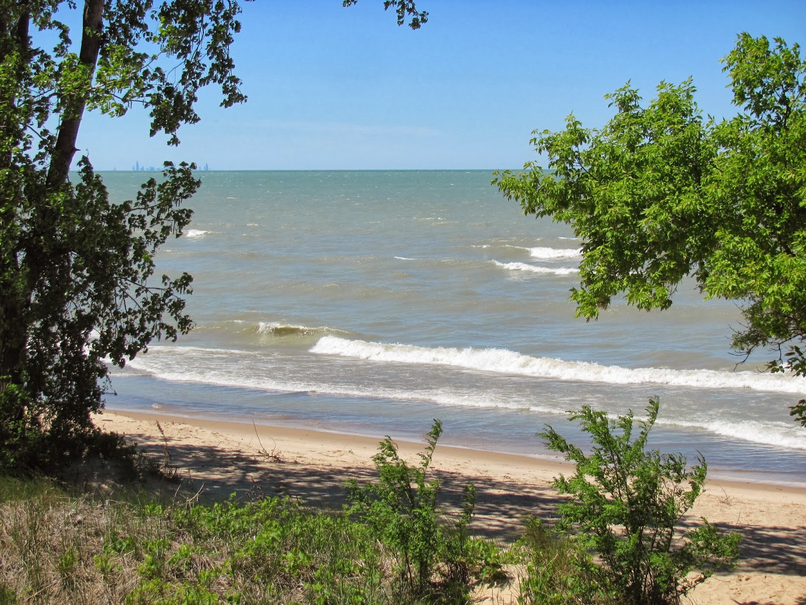
An Indiana Dunes National Lakeshore Beach and Lake Michigan, with the Chicago skyline on the horizon to the left
Now, we can all enjoy walks along the beaches, in the
woodlands, up the dunes, and through swamps, fens and other wetlands. Wildlife can continue to flourish.
We will return as soon
as we are able, to enjoy more of the Indiana Dunes, thanks to the good work of
other people.
The final goal of the Great Marsh restoration effort:
“Leave a natural resource legacy for future generations”.
“Leave a natural resource legacy for future generations”.
Here are some web sites that I used for information, and that
are interesting to explore to learn more about the Great Marsh and its
restoration:
Brochure: Great Marsh
Restoration At Indiana Dunes National Lakeshore
Indiana Dunes Wetland Restoration Team 2, 2012 (Student
Conservation Association)
Many photos of the Great Marsh Trail, including restoration
efforts. This also includes photos of
Cowles Bog, another part of the Great Marsh where restoration is taking place.
http://www.in.gov/dnr/files/lmcp-sheets/DerbyDitchHydrology_10.pdf
http://www.in.gov/dnr/files/lmcp-sheets/DerbyDitchHydrology_10.pdf
Derby Ditch Hydrology Habitat Restoration Analysis
http://www.beverlyshoresindiana.org/uploads/BevShrs_Comprehensive_Plan_Final_2012.pdf
http://www.beverlyshoresindiana.org/uploads/BevShrs_Comprehensive_Plan_Final_2012.pdf
“For the Town of Beverly Shores: A Comprehensive Plan: By the
Beverly Shores Plan Commission: Approved on October 22, 2012”