
We Did It!
The 3 Dune Challenge
May 29, 2014
Indiana Dunes National Lakeshore Visitors Center:
We were standing before a large map of the whole Indiana
Dunes area, staring at different locations, tracing various trails and
pondering what special thing we would do during this trip. Every time we go to
the Dunes we try something different, hike a different trail or two, or explore
another place. Should we return to a favorite trail from the past, such as
Cowles Bog? Should we re-try the one where we got lost (Li-Ko-Ki-We, cum
Dunewood Trace) and get it right this time? Or should we try one of the trails
we haven't experienced, such as the West Beach or Miller Woods Trails?
A very friendly guide came over to help us. That was when we
found out about the brand-spanking-new “3 Dune Challenge” - walk trails in
Indiana Dunes State Park between and to the tops of the three highest dunes: Mt.
Jackson (elevation 176 feet), Mt. Holden (184 feet) and Mt. Tom (192 feet). I
did have a goal of going to the top of Mt. Tom this time, so why not all three?
Richard agreed that we should take on The Challenge.
The official kick-off for the 3 Dune Challenge would not be
until Tuesday, June 17, and it would be quite an event. We would not be there
on June 17, but the park service already had the Challenge set up. Another plus
was that it would be cooler on May 29. From my experiences scrambling up and down
these steep, sandy places in my younger days, I knew I preferred not to do it
on a hot day.
So, off we went, state park map in hand.
What we didn't know at that early date was that the
“official” Challenge is a designated 1.5 mile trail route. Not knowing this, we
chose our own route, to visit each dune in a different order. It didn't matter
– getting to the top of each dune would be a big accomplishment for us, and we
looked forward to the spectacular views.

Indiana Dunes State Park, at the southern tip of Lake
Michigan, is approximately halfway between Gary and Michigan City, Indiana,
surrounded by Indiana Dunes National Lakeshore properties. It extends from lake
shore and beaches, through dunes and forest, and back to the swampy places
between two dunal areas. Some of my childhood was spent on the beaches, dunes
and trails here, making wonderful memories. My blog entry of July 2, 2013, “The
Great Marsh of the Indiana Dunes: the Backstory”, gives a good background on
the geologic history, formation and physical characteristics of this land.
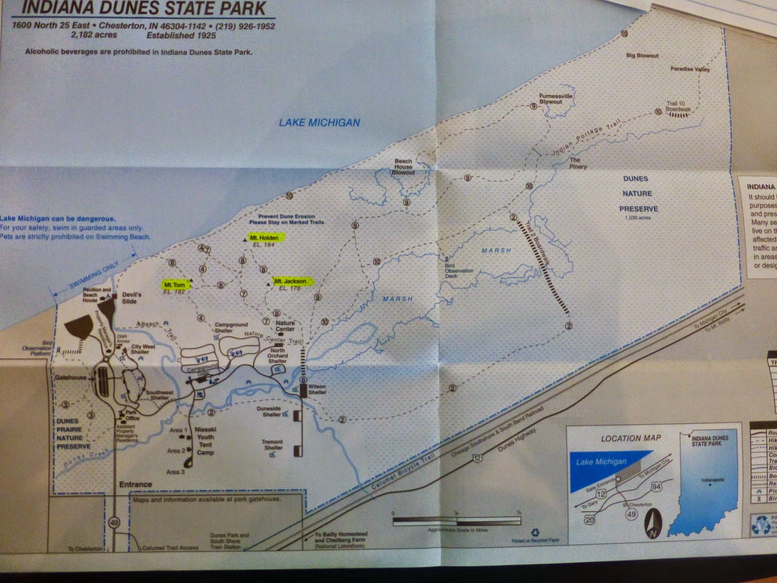
Map of Indiana
Dunes State Park
In late May of 2013, Richard and I walked all around the
Great Marsh in the state park, reported in “The Great Marsh of the Indiana
Dunes: Swamp-Walking in the Indiana Dunes State Park”, posted on July 14, 2013.
This time, we would have a much drier walk.

Map of state park, with three tallest dunes
highlighted.
We decided we would not tire ourselves at the beginning by
taking Devil's Slide or the beach straight up to Mt. Tom. We would start at the
Nature Center, take Trail 7/8 to Mt. Holden, back-track a little, take Trail 8
to Mt. Tom, back-track on Trail 8, go south on Trail 7, cut over to the eastern
part of Trail 8, then take that to the top of Mt. Jackson. We would go back
down Trail 8, cut back over to Trail 7, and back to the Nature Center. This was
definitely more back-tracking than the “official” trail.
After a brief stop in the Nature Center, we started off
nearby on Trail 7. Off we went on the
sandy trail through shady woods.

We were fortunate to be at the Dunes during this time, when
there are beautiful blooms.

Lupine (Lupinus
perennis) along Trail 7

Blueberry (Genus Vaccinium)
Probably either Highbush/Swamp Blueberry (V.
corymbosum) or Dryland/Late Low Blueberry (V. pallidum)

Maple-Leaved Viburnum (Viburnum acerifolium) in bud

Sand Cress, or Lyre-Leaved Rock Cress (Arabis lyrata)
A walking stick would be very helpful.

Richard on the
trail
Our first ascent was up the side of Mt. Holden. I found some
of my favorite dune-loving flowering plants here.

Hairy Puccoon (Lithospermum caroliniense)

Possibly Butterfly Weed Milkweed (Asclepias tuberosa)

Common Milkweed
(Asclepias syriaca)

Wild Grapes – don't know the species (Genus Vitus)
I did not know what this was, as it was not blooming yet, but
it looked a lot like Cosmos:

And – we reached the top!

Mt. Holden 184'
The view from the top of Mt. Holden, including Lake Michigan:


Richard's walking stick became a “dowsing rod” to find the
lake.

Back down Mt. Holden – our muscles were warmed up. I thought
about how different it is to climb up sand instead of a rocky or forested
slope. There is often nothing to hang onto, and every two steps forward result
in one step back. I had read that, in some parts of this area, slopes are
nearly 40 degrees.
I remember some very
laborious climbs, on all fours, in my earlier days, followed by fast, exhilarating
descents down the other side, when my legs, like those of a cartoon character,
would wheel and propel non-stop as if on their own.
Walks through breezy, shady forested trails were nice
respites between the dunes.


Richard resting on an old tree on Trail 8, between Mt.
Holden and Mt. Tom.
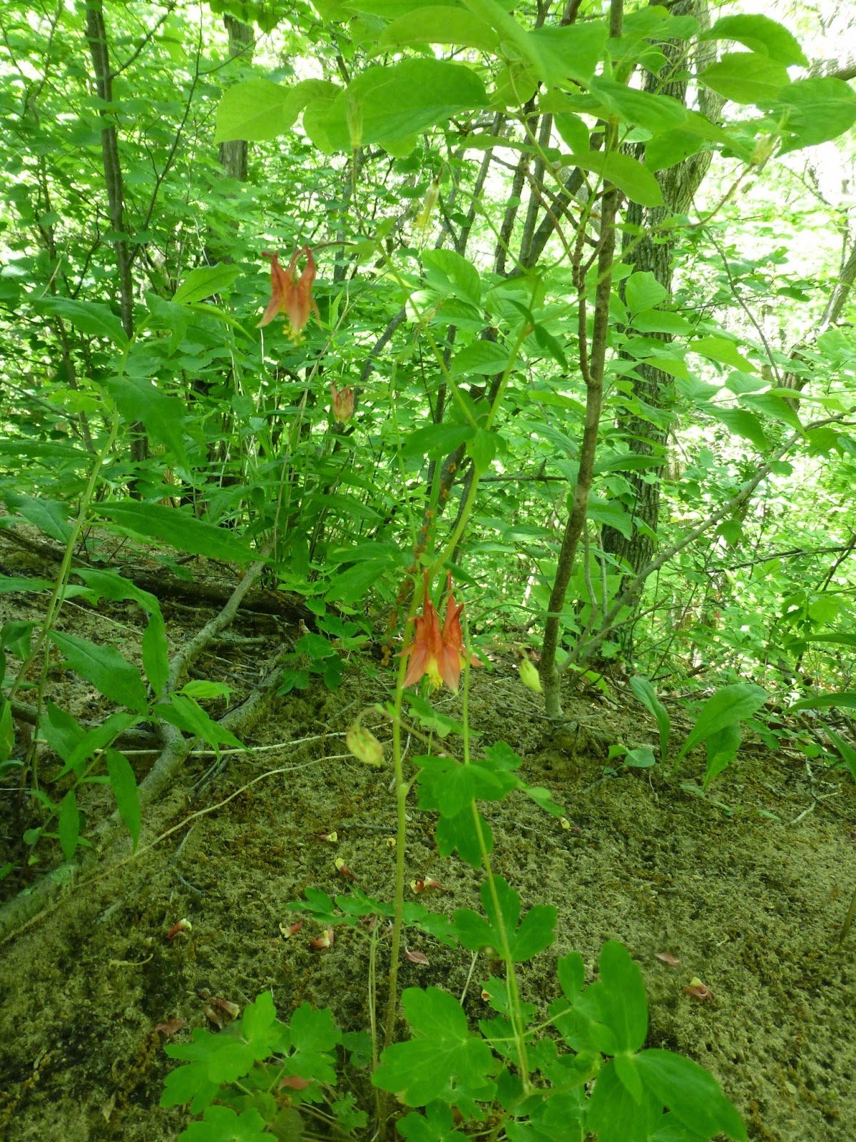
Native Columbine (Aquilegia
canadensis) ….

...and more Lupine in bloom.

The last of the shady trail to Mt. Tom
We reached the base of Mt. Tom, the tallest dune.

On the way up
Mt. Tom …


… to the top …

… where I am greeted by a little friend.

Top of Mt. Tom:
elevation 192 feet
Views from the top of Mt. Tom, panning east to west:

Looking east toward Michigan City


Looking north

Looking westward – steps going down the other side of
Mt. Tom toward the lake shore and Devil's Slide. I want to go that way
sometime.

Zooming in westward on the Burns Harbor area
Some geologic history:


5,500 years ago, the lake was all the way up here, at the
“Tolleston Beach” level. Earlier, at the “Calumet Beach” level and the
“Glenwood Beach” level, we would be under deep water. Retreating and advancing glaciers caused lake
levels and shorelines to change. Ridges, still visible in the Indiana Dunes
landscape, are the remaining evidence of various ancient lake levels.

After spending time taking in the spectacular views, it was
time to descend Mt. Tom and head to the next, and last, destination.


Interesting mushroom on Trail 8
More walking in the cool shade:


Dramatic tree roots exposed after sand blew away

Starry moss
We reached the bottom of Mt. Jackson and gathered steam for
our last ascent.

Climbing up Mt. Jackson was the most difficult, despite being the least high in the 3 Dune Challenge. The sand “trail” became very
wide, and it seemed to take so much more time and effort.


“Every two steps forward result in one step back”
We reached the top of Mt. Jackson, at 176 difficult feet
above sea level!
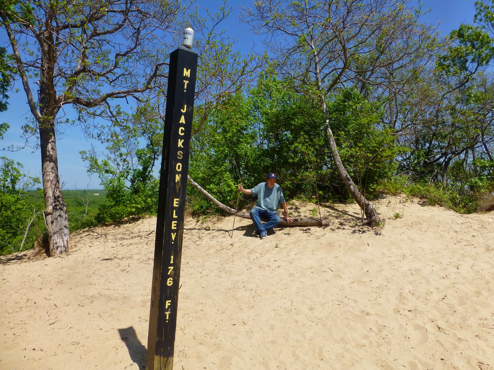
(By the way, that's not our beer can, but we wondered how someone got it on top of that pole.)

Views from the top of Mt. Jackson, which is further back from
the lake than the other two dunes:
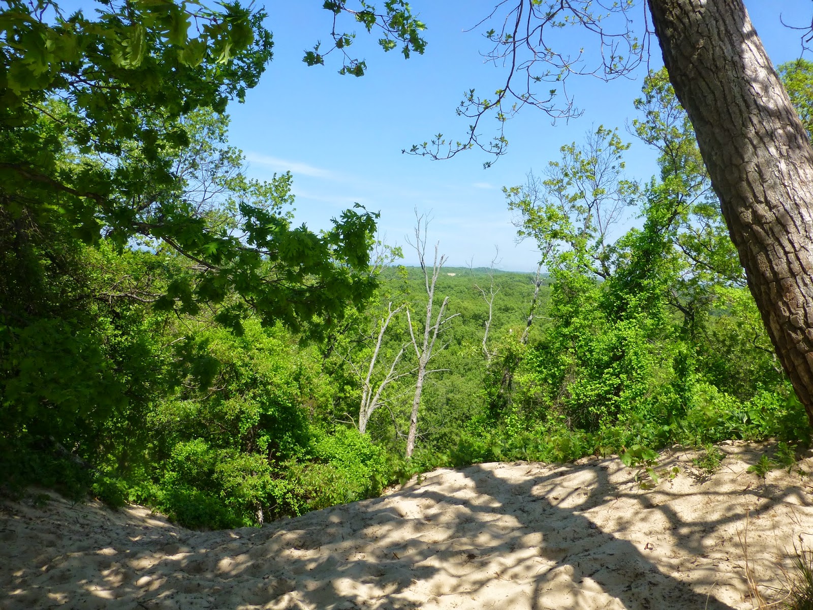
Looking northeast – the other side looks steeper. What
is that light spot in the distance?


Exposed sand. Could this be part of the Beach House
Blowout? It is hard to tell from here.

Looking eastward toward Michigan City

Zooming in toward Michigan City.


Looking northwest
It was time to go down Mt. Jackson, which would, undoubtedly,
be more fun than going up.


Running down the steep dune, as I had years ago.

It was all downhill from there, and in the shade - a nice
reward.

Heading back to the Nature Center

Bracken Fern (Pteridium
aquilinum)

I don't know this plant, but it was pretty.

More dramatic exposed tree roots – a good place for
fairies.
We Did It!
After returning to the Indiana Dunes State Park Nature Center
for drinks of water and cooling off, we drove back to the Indiana Dunes
National Lakeshore Visitors Center. There, we got a t-shirt that we earned the
privilege of buying and got some free postcards and stickers.


In between the Nature Center and Visitors Center, we made a
short stop at the lake and state park beach.


The Pavilion


Maybe one of our future visits will be taking the 3 Dune
Challenge again, using the “official” route. But, not on a hot day.
For more information on the 3 Dune Challenge and the Indiana
Dunes, check these web sites:
www.indianadunes.com/3dc (includes a short video and a small map of
the “official” Challenge trail)
www.ingov/visitindiana/blog/index.php/2014/06/17/3-dunes-challenge-indianadunes
(blog of Jake Oakman, reporting on the day of the official 3
Dunes Challenge Kick-Off)